


INDIANA – The National Weather Service (NWS) in Indianapolis says the remnants of Hurricane Beryl that hit Texas early Monday morning are expected to impact Indiana late Tuesday through early Friday.
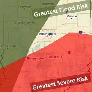
Heavy rains are likely with an isolated severe weather risk. Hurricane remnants can sometimes spawn isolated, weak, short-lived tornadoes with the highest potential across the highlighted area.
The heaviest rainfall is expected north and west of Bartholomew County, mainly Illinois and far northwest Indiana.
Bartholomew, Johnson, Jackson, Jennings, and Brown Counties are expected to receive the potential for severe weather including the threat of winds, low-end tornadoes (mainly south of I-69), heavy rainfall, and lightning.
The main timing for the onset of Beryl’s remnants is Tuesday evening into Wednesday morning. No Watches or Warnings have been issued for the area at this time however, a Flood Watch could be issued for some areas.
Weather potential could change based on how the storm tracks across land.